California's Ancient River
Of Gold
California's El Dorado -Secrets of Geology and finding gold treasure!

This 1945 map details places to look- having secret knowledge of gold geology- you can find a treasure!

Gold
You can avoid the cold water of rivers and streams by hiking along the ancient path of Eldorado high above the valleys below. The real gold bonanza lies high above the cold water dredges. The serious prospector and hiker seeks out ancient dry clays of white, pink, and grey; sampling and recording position as they hike along Eldorado's course a constant 2150' elevation using the terrain map as the guide. And don't forget to collect all the soil/clay unearthed while digging a nugget strike even if you didn't find the nugget. Most of these clays that make a sensitive metal detector "sing" contain fine gold.
Lindren's map would be more complete if the various ancient tertiary gravel channels were connected to a central ancient river; note that the Ancient Eldorado drawn over Lindgrin's map is located near the terminus of the ancient gravel deposits. The placer gold in Eldorado is from the mountain building episode that preceded the current Sierra Nevada; an entire mountain chain was eroded to deposit the gold in Eldorado. The path of Eldorado (in gold) is shown on Linden's original auriferous channels of tertiary gravels (in red) of the above image. The ancient river is offset by several miles and parallels the current Melones fault or Mother Lode. The old river followed the fault line of the previous mountain building time; it is logical that the current mountain (Sierra Nevada) building would produce a fault near the previous fault and parallel as well. Explanations follow as to why Amador County accounts for the highest placer gold production along the southern half of the Mother Lode and why the ancient river, Eldorado, is responsible.
Gold
Jan 09, 2021 Gold price USD $1932/ oz.
Aug 05, 2021 Gold Price USD $1806/oz.
Feb 14, 2022 Gold Price USD $1872/0z.
May 12, 2023 Gold Price USD $2022/oz.
How old are the Sierra Nevada mountains? For decades the prevailing thinking among geologists was that the mountain chain was 2-5 millions of years old. But recent studies indicate the mountains may be much older; perhaps starting to build some 40 million years ago. That would make Lindgrin's ancient channels older than 40 million years. The new mountain chain lofted the ancient gravels to new heights and also the central river into which all the ancient channels drained; Ancient Eldorado. Only Eldorado received the eroded and concentrated gold from the ancient tributary rivers. The new rivers created by the new Sierra uplift left the ancient channels high and dry but cut across Ancient Eldorado at right angles.
Gold
Below these towns and closer to Hwy49 are towns rich in placer gold that were already wet-close to water-on a creek or river: Melones, Angles Creek, Mokeloumne Hill, Chile Gulch, and many more.
What's the significance of differentiating gold camps? Answer: The Hwy 49 and towns immediately on it marks the approximate path of Ancient Eldorado, being offset by a few miles in most cases. The rich placer towns above the Hwy49 set directly on the course of Ancient Eldorado! All the camps on Hwy49 received their gold hordes by erosion of the Ancient Eldorado that is located just a little higher in elevation and a short distance to the east!!
The real secret is found by examining the common thread that connects all these Eldorado gold camps ......the elevation of the camps. For 120 miles from Georgetown to Sonora the gold camps and Ancient Eldorado set at an elevation of 2150+/- feet above sea level! The ancient river bottom is as flat as a pancake!!!
Don't believe it; let's list the elevation of some gold towns:
Sonora: 1880'
Columbia: 2145'
Murphys: 2170"
Soldier's Gulch and Volcanoe: 2150'
The geology action that led to this enormous flat gold deposit was plate tectonics. Long ago the American plate and the Pacific plate collided creating a high Sierra mountain chain. The heat and pressure of this collision forced gold laden quartz into the rising granite plutons. The gold was slowly eroded from the rock and flowed into an ancient River Eldorado that flowed north to south, much like today's Sacramento River. The ancient river was penned to the north to south flow by a later and lesser collision that forced up coastal mountains. Remnants of these parallel the Sierras and are sometimes called the Bear mountains. During these collisions masses of seafloor muds and limestone were forced up in great sheets over the lower portions of the rising granites. Erosion continued for millions of years producing what are called tertiary gravels. In all, the once great chain of mountains was reduced by erosion to a low flat plain through which Ancient Eldorado meandered and concentrated gold from the gravels in oxbows and deep channels cut down in the limestone. The river dropped slowly in elevation and emptied into a briny inland sea.
The quiet time was ended by the current collision of the two great plates and the rebirth and rise of the current Sierra Nevada chain. In rising, the plutons of the south rose modestly faster and higher than the northern plutons and the downslope of the Ancient Eldorado was eliminated by the differing rise. The rise difference or tilt of the mountain(s) was opposite the old river fall creating the river bed of gold at a constant elevation. That elevation is 2150' in the 120 mile stretch of the river between Georgetown and Sonora. The area surrounding the river was also very flat so that occasional pockets of placer gold is found just off the river's course.
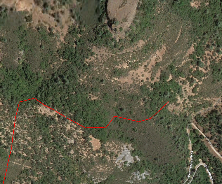
In the map at the top of the page, a short section of the Cataract and Yahoo gulch is shown just southeast of Murphys. Here, the Ancient Eldorado is boldly outline by volcanic rock and mudflow deposits that filled the meanders of Eldorado. It must be noted that the mixed geology here complicates the situation; something similar to this is found in most all analysis of the old river's course. Several rivers are involved here; old Stanislaus, new Stanislaus, and Ancient Eldorado. As the latest mountain chain emerged from the deep magma, volcanic ash and mudflows buried the gold and filled the Ancient Eldorado meanders and oxbow cutoffs. The original Stanislaus grew over time to a mighty straight moving river that cut right through the mud and ash clogged meanders of Ancient Eldorado. A later volcanic spasm filed the valley of old Stanislaus with molten volcanic rock creating what is known today as Table Mountain. Blocked by the hard rock, the river drainage found a new path parallel to the old and that's the Stanislaus river known today. The canyon of the Stanislaus is like most Sierra canyons; big and rugged terrain.

Here the course of Eldorado is marked by the heavy black line and this line is at a depth below the terrain surface; elevation=2150'. Note that the bottom of the river(gold color) is exposed in the immediate area of the green lines. The erosion of the river gravels here was the source of the gold for the short lived Cataract Gulch and Yahoo Gulch strikes. These were rich placers that were depleted in a matter of months after discovery. The mine markers (shovel and pickaxe) to the right at elevation 2150" are modern era indicators of placer mining of small deposits made in the temporary oxbow lakes created by the ancient river's meander. So searching or sampling along the 2150' level in this area should show good results. This example points out the rule of thumb: when handy do do so, search along the 2150' elevation terrain lines on the maps of the area.
The miners of 49 cleared the overburden of eroded volcanics out of Cataract Gulch up to a point just below the 2150' elevation. The exposed Calaveras limestone can be clearly seen in the close up satellite photo using Google Earth. Had the miners continued on sampling up the slope, the river bottom's thin gold ribbon may have been found a few feet below the earthen soil surface. Here the ancient river has straightened out and the gold would be very thin. Gold accumulates in the curve of water's flow and flushes out to a mere thread in the straightaways. Learning to follow that thread is the key to finding the next curve and it's bonanza of gold.
Gold

The flow of the Ancient Eldorado in the satellite image of the terrain is marked and the same as the map. Note the differences between the flow of Eldorado and the old Stanislaus as highlighted by the volcanic flows that covered both rivers. The slow meander of Eldorado versus the quicker direct flow of old Stanislaus. The old Stanislaus cuts through Eldorado just above (north) of the area depicted on the map; and new Stanislaus cuts through Eldorado just below the pictured area. That area will be examined later.
A note here about gold distribution in the old Eldorado- as in every case the gold is concentrated in the bends of the river bed and deep channels cut into the limestone; and almost no gold in the straight sections of the river. This leads to wide distribution and abundance and shortly thereafter razor thin lines of gold that disappear in the clutter of rocks and mud. This explains why the 49er's couldn't simply continue to follow the river bed. The tiny thread of gold was lost in the digging. They recovered only about 10% of the gold in Eldorado. A modern method of following the gold thread will be discussed later.
A drift under the lava cap here would be similar to the efforts of the Humbug mine near Jamestown except a great deal more profitable. The problem in the Humbug was water and the expense of pumping the water and keeping the mine dry. At the Cataract, the water, if it's a problem, would be simply channeled out of the mine by gravity to the settling pond and hence on to the lake below. The placer gold under Cataract could be mined using the modern boring machine capable of moving through the softer volcanics and limestone bedrock at a fast pace. The further advantage is that the Cataract would be on the Ancient Eldorado river bottom while the Humbug was placed on the bed of the old Stanislaus. The tail end of the volcanic marker (Table Mountain) of the old Stanislaus does meander enough as it approached it's terminus to make it look like the ancient river. However, the lava cap marker does not have the huge looping meaner of the Ancient Eldorado.
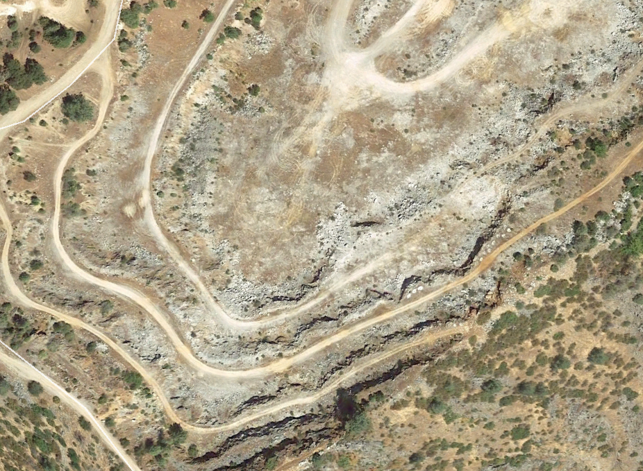
The above image is the lower half of the abandoned Calaveras Cement limestone quarry just below the Cataract Gulch. The quarry was in operation only about 10 years and in it's final years was actually a placer gold mine posing as a limestone/cement quarry. A minor amount of gold was reported here. The new Stanislaus cut down through the Eldorado and left several narrow channels with gold eroded from the Eldorado just above. The channels are at 1940' some 200 feet below Eldorado. This is very similar to the river geology that created the bonanza at Mokeloumne Hill. It's only importance is that it helps mark the path of Eldorado.